
News Summary
Residents of North Carolina’s Outer Banks are on alert as Hurricane Erin, a powerful Category 3 storm, brings a tropical storm watch and mandatory evacuations. The storm is causing life-threatening rip currents and is expected to produce substantial beach erosion and flooding. Evacuations are underway in areas such as Hatteras Island and Ocracoke Island due to rising floodwaters. Beachgoers are advised to stay out of the water amid the increasing risk of rip currents as the storm approaches. Staying informed of any developments is crucial as Erin continues its path toward the U.S. East Coast.
Hurricane Erin Triggers Tropical Storm Watch and Evacuations in North Carolina’s Outer Banks
Heads up, Outer Banks residents and beach lovers! North Carolina’s beautiful Outer Banks region is currently under a **tropical storm watch** because of Hurricane Erin, which has been making quite the splash in the Atlantic. This powerful storm, now classified as a **Category 3**, has caused quite the stir and is affecting many along the coast.
Over the weekend, Erin picked up steam at a **historic rate**, bringing life-threatening rip currents and towering waves that could be dangerous for anyone thinking about hitting the water. The tropical storm watch stretches from **Beaufort Inlet to Duck**, covering all the way through the **Pamlico Sound**. Residents can expect sustained winds between **39 to 73 mph** within the next 48 hours as the storm continues to churn offshore.
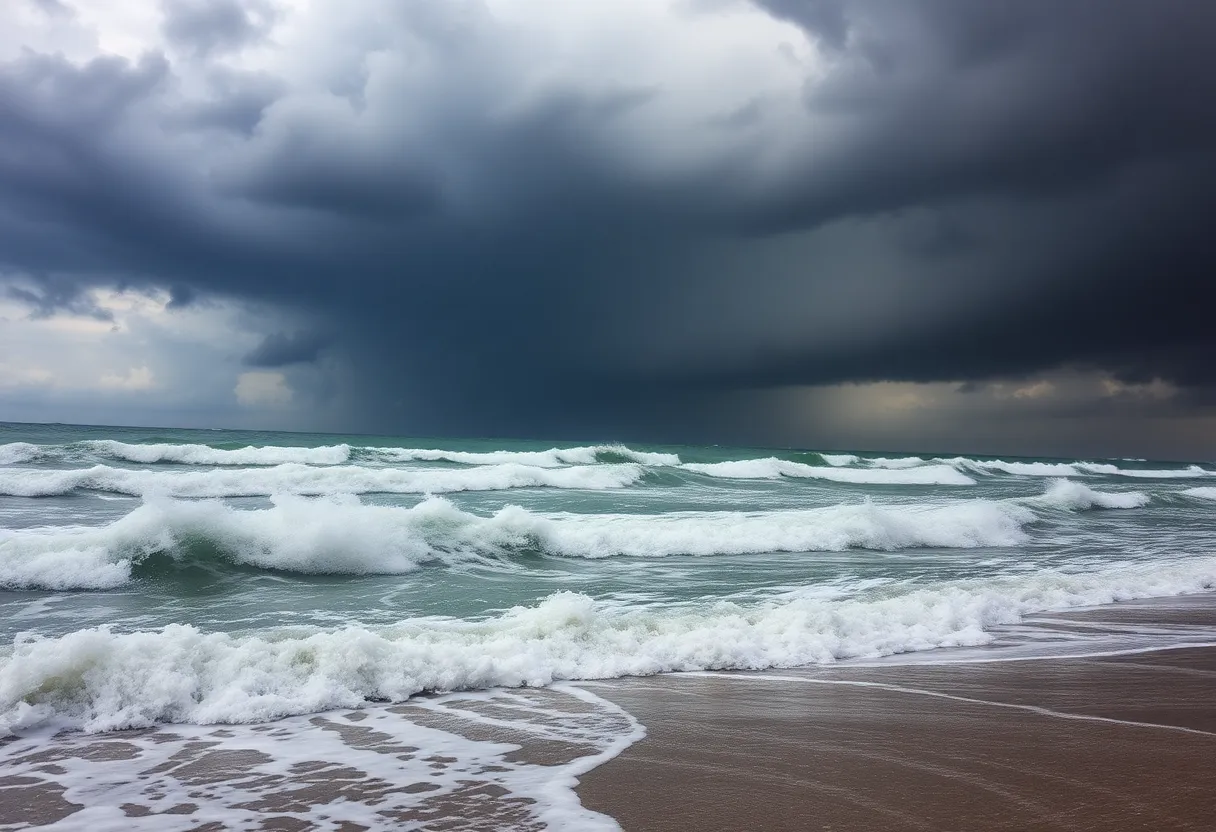
Watch Out for Rip Currents and Beach Warnings
This marks the **first tropical storm watch** of the year for the Outer Banks, and it comes with serious warnings. Rip currents have already been creating challenges, with at least **75 rescues** reported in New Hanover County. Fortunately, there have been no injuries, but it’s still a reminder of how powerful the ocean can be.
Currently, a **no-swim advisory** is in effect for **Wrightsville Beach** from August 19 through August 22. This is due to strong rip currents that are expected to worsen as Hurricane Erin approaches. The **National Weather Service** is cautioning everyone to take these warnings seriously, as even the calmer-looking surf can be deceptive.
Prepare for Potential Flooding
As the storm progresses, areas like Dare County have declared a **local state of emergency**, issuing mandatory evacuation orders for **Hatteras Island**. Coastal flooding and ocean overwash are expected from Tuesday through Thursday, potentially making **N.C. Highway 12** impassable. Nearby Hyde County is also taking precautions and has issued similar evacuation orders for **Ocracoke Island** due to rising floodwaters.
Beachgoers should brace for **wave heights** of **20 feet or more** this week, which could result in extensive beach erosion and threaten protective dune structures. Added to that, the tides are expected to be at their highest levels of the month on Wednesday and Thursday, increasing flood risks even more.
Keeping Safe Amid Rising Danger
The rip current risk will sharply increase from Florida all the way to New England between Tuesday and Thursday. And don’t let the sunny skies fool you! Reports indicate that at least **44 people** have lost their lives this year due to rip currents and other surf-zone hazards across the U.S. Staying out of the water is a top priority for anyone near the coast.
Meanwhile, in Puerto Rico, heavy rainfall has started to ease, but the area remains under a flood watch. Residents should expect additional rainfall of up to **6 inches** in some places, while **Howard Hamilton International Airport** on Providenciales had to close due to Erin’s impact but is set to reopen on Tuesday morning.
What’s Next with Hurricane Erin?
Erin is predicted to curve north-northeast between the U.S. East Coast and Bermuda, avoiding landfall. This hurricane is expected to remain a major Category 3 or greater storm through at least midweek. The outer rainbands are causing flash flooding and power outages in Caribbean regions, affecting the Southeast Bahamas and the Turks and Caicos Islands.
Interestingly, Erin rocketed from a tropical storm to a Category 5 hurricane in under 30 hours, marking one of the fastest **rapid intensifications** on record. It serves as a poignant reminder of how swiftly storms can strengthen, particularly as our climate warms.
Lastly, if you hear about **new disturbances** in the Atlantic, note that meteorologists are keeping an eye on those too. With the ocean being as tumultuous as it is, staying informed is key to everyone’s safety!
Deeper Dive: News & Info About This Topic
- CNN: Hurricane Erin Impacts
- USA Today: Hurricane Erin Updates
- NBC News: Climate Change and Hurricane Risk
- Weather.com: Major Hurricane Erin
- Wikipedia: General Knowledge
- Google Search: Hurricane Erin

Author: STAFF HERE ORLANDO WRITER
ORLANDO STAFF WRITER The ORLANDO STAFF WRITER represents the experienced team at HEREOrlando.com, your go-to source for actionable local news and information in Orlando, Orange County, and beyond. Specializing in "news you can use," we cover essential topics like product reviews for personal and business needs, local business directories, politics, real estate trends, neighborhood insights, and state news affecting the area—with deep expertise drawn from years of dedicated reporting and strong community input, including local press releases and business updates. We deliver top reporting on high-value events such as Orlando International Fringe Theatre Festival, Megacon Orlando, and Central Florida Fair. Our coverage extends to key organizations like the Orlando Economic Partnership and Hispanic Chamber of Commerce Metro Orlando, plus leading businesses in leisure and hospitality that power the local economy such as Walt Disney World Resort, AdventHealth, and Universal Orlando. As part of the broader HERE network, including HEREJacksonville.com, HEREPetersburg.com, HERETallahassee.com, and HERETampa.com, we provide comprehensive, credible insights into Florida's dynamic landscape.